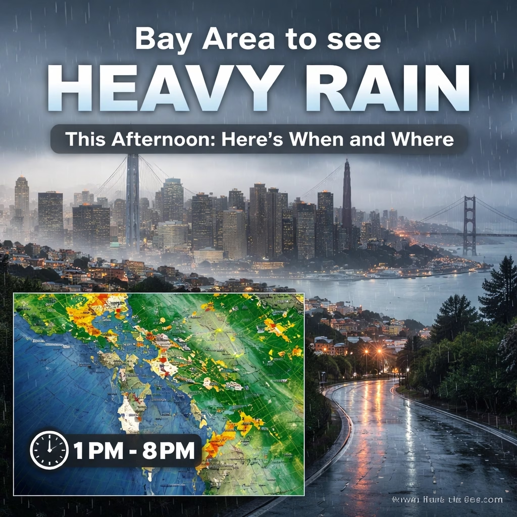


A powerful atmospheric river is set to unleash widespread heavy rainfall across the San Francisco Bay Area this afternoon, bringing significant precipitation, strong winds, and the potential for localized flooding and disruption. Residents across all nine Bay Area counties are advised to prepare for a rapid onset of severe weather, with the most intense downpours expected to begin in the late afternoon and persist into the evening.
Background: A Familiar Winter Visitor Returns
The incoming weather system is a classic "atmospheric river," a long, narrow plume of moisture stretching thousands of miles across the Pacific Ocean, often referred to as a "Pineapple Express" when originating near Hawaii. This particular system is forecast to tap into subtropical moisture, enhancing its capacity to deliver substantial rainfall. While California has experienced a relatively dry start to its winter season in some areas, this storm marks a significant shift, bringing much-needed precipitation but also posing immediate hazards.
The National Weather Service (NWS) has been tracking this system for several days, issuing initial advisories for potential heavy rain and wind earlier in the week. Forecast models consistently showed the storm's trajectory aiming directly at the Bay Area, prompting increased vigilance from local emergency services and public works departments. Historically, such atmospheric river events have been responsible for some of the region's most severe flooding incidents, particularly in areas prone to inundation or near burn scars. The ground, while not completely saturated, will quickly become overwhelmed in many locations due to the intensity of the expected rainfall.
Key Developments: Forecast Sharpens for Afternoon Onslaught
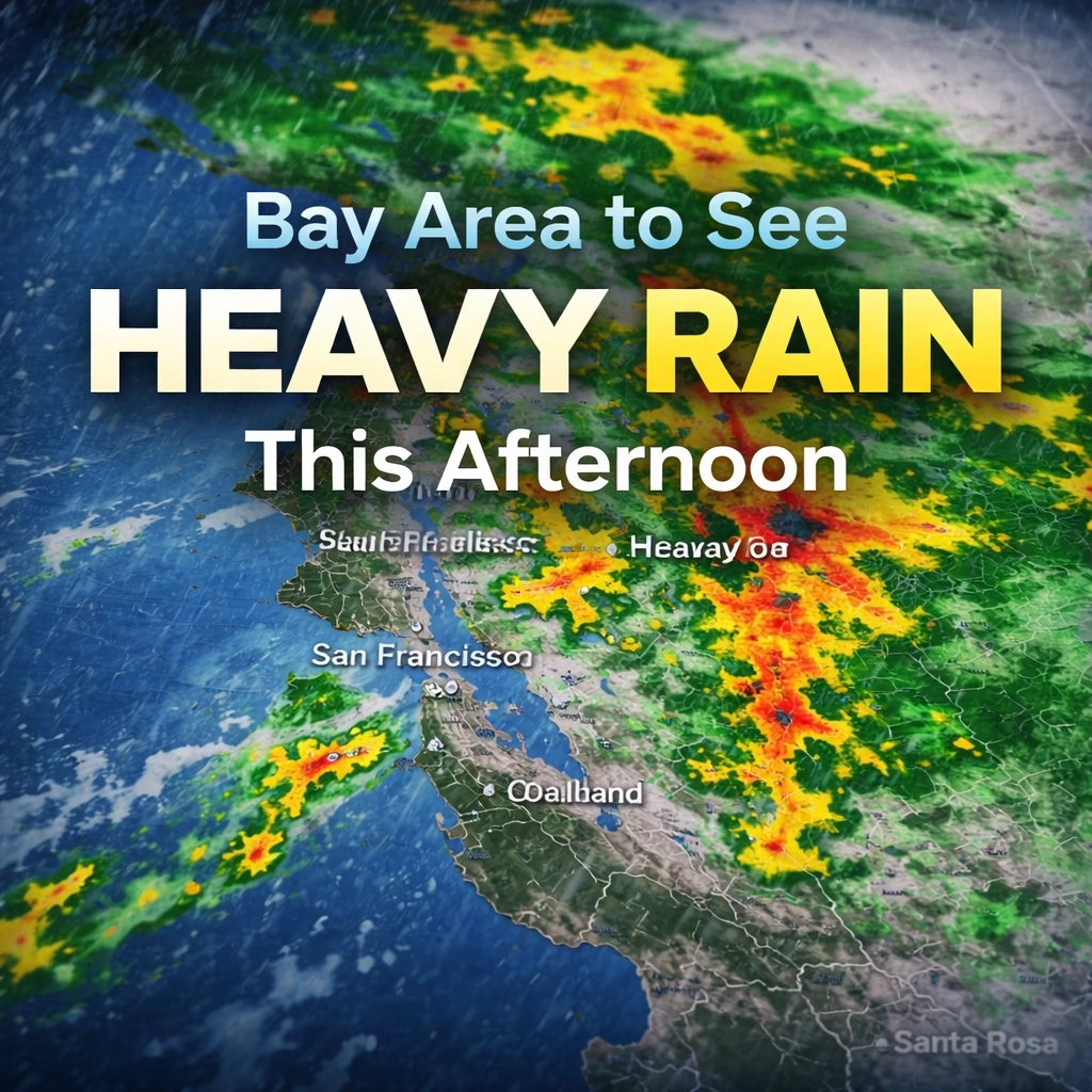
Recent updates from the NWS San Francisco Bay Area office confirm that the core of the atmospheric river is now making landfall in Northern California, with its leading edge already bringing light to moderate rain to coastal areas of the North Bay. The heaviest precipitation is projected to sweep through the region between 3:00 PM and 9:00 PM PST today, impacting the evening commute significantly.
Rainfall Totals and Intensities
Forecasters anticipate rainfall rates could reach between 0.5 to 1 inch per hour in the most intense bands, particularly across coastal ranges and higher elevations. Total rainfall accumulations are expected to range from 2 to 4 inches for most urban areas, with isolated pockets in the coastal mountains, such as the Santa Cruz Mountains and the North Bay hills (e.g., Sonoma and Marin counties), potentially receiving 5 to 7 inches. These high rates increase the risk of flash flooding, even in areas not typically prone to it.

Wind Gusts and Timing
In addition to heavy rain, strong winds will accompany the system. Sustained winds of 20-30 mph are expected across the region, with gusts potentially reaching 40-50 mph in exposed coastal areas and higher elevations. The strongest wind gusts are likely to coincide with the peak rainfall period, exacerbating hazardous driving conditions and increasing the potential for downed trees and power lines. A Wind Advisory is in effect for much of the Bay Area from this afternoon through late tonight.
Impact: Widespread Disruption Expected
The combination of heavy rain and strong winds is set to create a challenging environment across the Bay Area, affecting transportation, infrastructure, and daily life. Local authorities urge residents to stay informed and take necessary precautions.
Urban and Small Stream Flooding
Low-lying areas and urban centers are at significant risk of localized flooding. Cities like San Francisco, Oakland, San Jose, and Santa Rosa, with their extensive impervious surfaces, are particularly vulnerable to overwhelmed storm drains and street flooding. Creeks and small streams, especially in the North Bay (e.g., Napa River tributaries, Sonoma Creek) and the Santa Clara Valley (e.g., Guadalupe River, Coyote Creek), are expected to rise rapidly, potentially exceeding bank full capacity in some locations. Residents in flood-prone neighborhoods should have sandbags ready and clear storm drains near their properties.
More Read

Transportation Gridlock
Commuters face severe delays and hazardous conditions. Major freeways, including U.S. Highway 101, Interstate 80, Interstate 580, and Interstate 680, are likely to experience reduced visibility, standing water, and increased accident risks. Caltrans advises against non-essential travel during the peak storm hours. Public transit systems like BART and Caltrain may experience service disruptions due to track debris, signal issues, or power fluctuations. San Francisco International Airport (SFO), Oakland International Airport (OAK), and Mineta San Jose International Airport (SJC) are all likely to see flight delays and cancellations, with airlines urging passengers to check flight statuses before heading to the airports.
Power Outage Preparedness
Pacific Gas and Electric Company (PG&E) has issued alerts regarding the potential for widespread power outages due to strong winds and saturated ground increasing the risk of falling trees and branches onto power lines. Residents are encouraged to have flashlights, charged portable devices, and emergency kits readily available. PG&E crews are on standby to respond to outages as quickly and safely as possible.
Coastal Hazards and Landslides
Coastal communities, including Pacifica, Half Moon Bay, and areas along the Sonoma and Marin coasts, should prepare for high surf, strong rip currents, and potential coastal erosion. Large waves could generate sneaker waves, posing a danger to beachgoers. Furthermore, areas recently affected by wildfires, such as parts of the Santa Cruz Mountains (CZU Lightning Complex burn scar) and the North Bay (LNU Lightning Complex burn scar), face an elevated risk of mudslides and debris flows, even with moderate rainfall, due to compromised soil stability.
What Next: Lingering Effects and Clearing Skies
The heaviest rain is forecast to taper off by late tonight and early Friday morning, transitioning to scattered showers throughout Friday. However, the impacts will linger beyond the immediate storm period.
Post-Storm Watch
Even after the main system passes, the risk of localized flooding will persist as rivers and creeks continue to swell. Emergency services will remain vigilant, particularly for areas prone to landslides or where water levels are slow to recede. Residents should avoid driving through flooded roads, as even shallow water can hide significant hazards.

Weekend Outlook
The forecast for the upcoming weekend indicates a significant improvement in weather conditions. Saturday and Sunday are expected to bring partly cloudy skies, significantly lighter winds, and much cooler temperatures. This will provide a window for clean-up and damage assessment. However, temperatures are projected to drop, especially overnight, raising concerns for potential frost in inland valleys.
This atmospheric river serves as a powerful reminder of California's dynamic winter weather. While the rain is beneficial for the state's water reserves, the immediate challenges require careful attention and preparedness from all Bay Area residents. Stay tuned to local weather advisories and emergency alerts for the latest information.