


Antarctica's Hidden World Uncovered
Unprecedented Map Reveals Antarctica's Secret World: Mountains, Canyons, and Rivers Hidden for Millennia
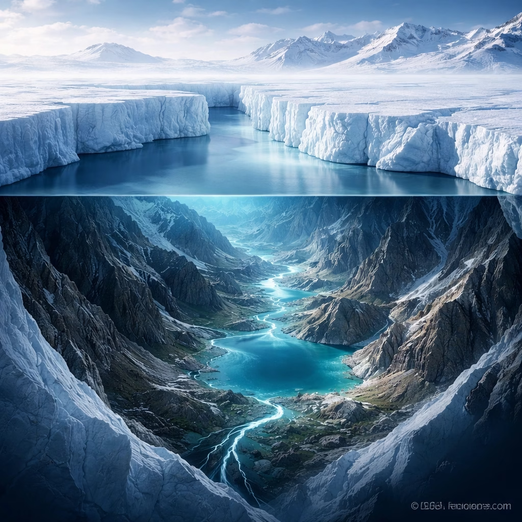
Scientists have unveiled the most detailed topographic map ever created of the landscape beneath Antarctica's vast ice sheet. This groundbreaking achievement provides an unprecedented look at the continent's hidden geology, revealing a complex world of towering mountains, deep canyons, and extensive river systems previously obscured by miles of ice. The new dataset, compiled from decades of radar soundings and satellite measurements, offers critical insights into the dynamics of the Antarctic ice sheet, its past behavior, and its potential future contributions to global sea level rise.
Background: Peering Beneath the Ice
For over a century, the true shape of the Antarctic continent beneath its immense ice cover remained largely a mystery. The ice sheet, which averages over 2,000 meters thick and in some places exceeds 4,000 meters, has historically made direct observation of the bedrock impossible.
Initial efforts to map the subglacial landscape began in the mid-20th century, primarily utilizing seismic surveys and sporadic airborne radar soundings. These early expeditions, often conducted under harsh conditions, provided tantalizing glimpses of a varied terrain but lacked the resolution and coverage needed for a comprehensive understanding.

The first major pan-Antarctic subglacial topography map, BEDMAP1, was released in 2001, followed by BEDMAP2 in 2013. These earlier versions, while revolutionary for their time, relied on sparser datasets and lower-resolution techniques, leaving significant gaps and uncertainties, particularly in remote and challenging areas like East Antarctica and portions of the Transantarctic Mountains.
The impetus for these mapping efforts stems from the critical role subglacial topography plays in controlling ice flow. The shape of the bedrock dictates how ice moves, where it accelerates, and where it may be vulnerable to thinning and retreat, directly impacting global sea levels.
More Read

Key Developments: A New Era of Detail
The recently released map, often referred to as BEDMAP3 in scientific circles, represents a monumental leap forward in precision and coverage. It integrates an enormous volume of new data collected over the past decade, combining sophisticated airborne radar measurements with advanced satellite altimetry from missions like NASA’s ICESat-2 and ESA’s CryoSat-2.
This enhanced dataset now boasts an average resolution significantly finer than previous iterations, often providing bedrock elevations at scales of hundreds of meters across vast swaths of the continent. The sheer volume of new radar flight lines, particularly over previously unmapped areas, has been instrumental in filling critical data gaps.
Revealing Hidden Features
Among the most striking revelations are the detailed portrayals of previously hypothesized, but now clearly defined, subglacial features. The map illuminates intricate networks of subglacial river valleys, some extending for hundreds of kilometers, suggesting complex hydrological systems beneath the ice that influence ice sheet stability.
It also provides unparalleled detail on major subglacial mountain ranges, such as the Gamburtsev Subglacial Mountains in East Antarctica, whose peaks rival the European Alps in height, and the Transantarctic Mountains, which dissect the continent. Conversely, it precisely delineates deep subglacial troughs and basins, including the colossal Bentley Subglacial Trench, one of the deepest depressions on Earth not covered by ocean, plunging more than 2,500 meters below sea level.
Crucially, the new map offers refined views of the bedrock topography beneath rapidly changing regions, such as the Thwaites Glacier and Pine Island Glacier in West Antarctica. These “doomsday glaciers” are known for their rapid melt rates and significant contributions to sea level rise. Understanding the exact contours of the bedrock here is vital, as features like retrograde slopes (sloping downwards inland) can accelerate ice retreat by allowing warm ocean water to penetrate further beneath the ice.
Impact: Understanding a Changing World
The implications of this unprecedented mapping effort are far-reaching, influencing multiple scientific disciplines and informing global policy.

For glaciologists, the detailed bedrock topography is a game-changer. It enables the creation of significantly more accurate ice sheet models, improving predictions of how the Antarctic ice sheet will respond to future climate warming. Better models mean more reliable forecasts of ice flow speeds, thinning rates, and the potential for marine ice sheet instability, especially in vulnerable regions.
Climatologists and oceanographers will benefit from enhanced understanding of freshwater discharge into the Southern Ocean, which can influence ocean circulation patterns and global climate systems. The improved precision in calculating ice volume and potential meltwater contributions directly feeds into more robust projections of global sea level rise, impacting coastal communities worldwide.
The revelations also hold profound interest for astrobiologists and biologists. The detailed mapping of subglacial lakes, such as Lake Vostok, Lake Mercer, and Lake Whillans, and their connecting river systems, provides crucial context for understanding potential isolated ecosystems. These subglacial environments are considered analogues for potential life on icy moons like Europa and Enceladus, making their detailed topography essential for future exploration and research into extremophiles.
Ultimately, this scientific advancement provides policymakers and governments with more robust data to formulate strategies for climate change adaptation and mitigation. Accurate sea level rise projections are fundamental for urban planning, infrastructure development, and disaster preparedness in coastal areas globally.
What Next: Future Frontiers of Discovery
While the new map marks a significant milestone, it also paves the way for future research and exploration. Scientists are already planning to integrate this high-resolution topography into the next generation of ice sheet and climate models, leading to even more refined predictions of Antarctica’s future.
Further targeted airborne radar surveys will continue to fill remaining smaller gaps and increase resolution in critical areas, particularly those experiencing rapid change or presenting unique geological features. The development of autonomous underwater vehicles (AUVs) capable of operating beneath the ice shelves is also a key area of focus, promising direct observation and sampling of the subglacial ocean and lake environments.
Long-term monitoring through satellite missions will continue to track changes in ice thickness and surface elevation, providing real-time data to validate and improve the models built upon this new bedrock map. The scientific community anticipates that this foundational dataset will spark numerous new research projects, from investigating the geological history of the continent to exploring the limits of life in extreme subglacial habitats.
The journey to fully understand Antarctica’s hidden world is ongoing, but this unprecedented mapping effort has brought humanity closer than ever to revealing the true contours of Earth’s enigmatic southernmost continent.


