


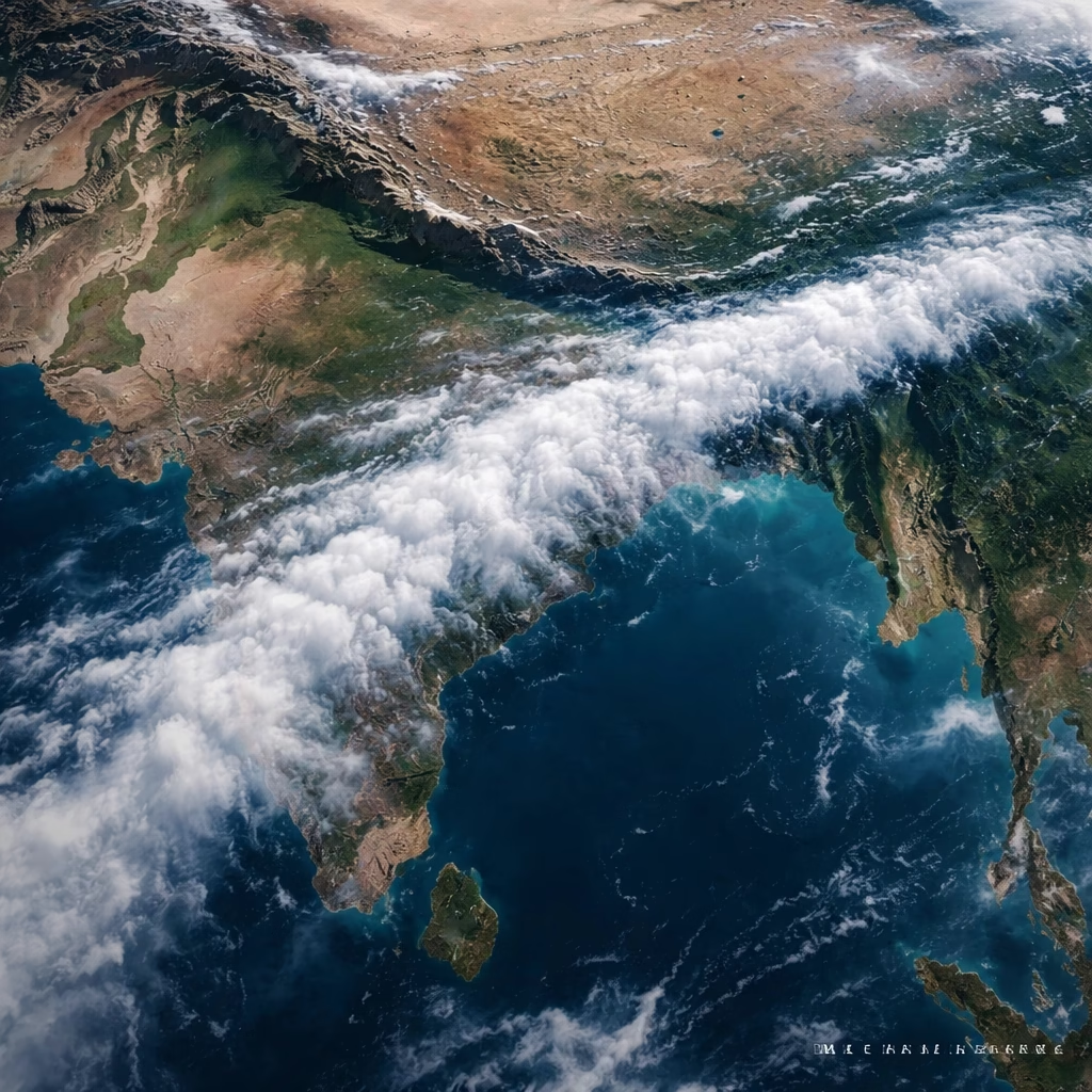
Satellite Unveils Monsoon's 1,500km Atmospheric Artery Across India
A remarkable satellite image recently captured a colossal 1,500-kilometer-long monsoon rain band, stretching uninterrupted from the Bay of Bengal across the vast plains of northern India to the mountainous terrain of Kashmir. This unprecedented visualization, observed in early August 2023, offers meteorologists and policymakers a unique perspective on the intricate dynamics of the Indian monsoon system and its expansive reach.
Background: The Lifeline of India’s Climate
The Indian Summer Monsoon, a complex meteorological phenomenon occurring primarily from June to September, is the lifeblood for nearly a billion people across the subcontinent. It accounts for approximately 70-90% of India's annual rainfall, directly influencing agricultural output, water security, and the overall economy. The monsoon's rhythm dictates the planting and harvesting cycles of vital crops like rice, maize, and sugarcane, making accurate forecasting and real-time monitoring critical.
Traditionally, monsoon rainfall patterns are observed through a network of ground-based weather stations, radar systems, and occasional aircraft reconnaissance. However, these methods often provide localized data, making it challenging to grasp the full, continuous scale of large-scale weather phenomena. The advent of advanced meteorological satellites has revolutionized this capability, offering synoptic views that reveal the interconnectedness of weather systems over vast geographical areas.
India operates its own series of geostationary meteorological satellites, such as the INSAT-3D and INSAT-3DR, which continuously monitor weather patterns, including cloud cover, rainfall intensity, and atmospheric temperature profiles. These satellites, alongside international platforms like those from NOAA and EUMETSAT, provide crucial data for daily weather forecasts and long-term climate studies. This 1,500-km rain band highlights the immense potential of orbital observatories to detect and track significant weather events, especially those whose true scale might otherwise be underestimated. Such extensive, coherent bands, while part of monsoon variability, are not routinely observed with this clarity and length, underscoring this capture's exceptional nature.
More Read

Key Developments: A Ribbon of Rain
The satellite imagery, specifically from an advanced very high resolution radiometer (AVHRR) instrument aboard a geostationary satellite, was processed by the India Meteorological Department (IMD) on August 4, 2023. It distinctly showed a continuous, high-intensity cloud band originating over the northern Bay of Bengal, traversing through West Bengal, Bihar, Uttar Pradesh, Uttarakhand, Himachal Pradesh, and culminating over Jammu & Kashmir. This remarkable ribbon of moisture-laden clouds and associated rainfall was directly linked to the active phase of the monsoon trough.
Meteorological Interpretation
Meteorologists have attributed the formation and persistence of this elongated rain band to a confluence of factors. A prominent low-pressure area had developed over the Bay of Bengal, drawing significant moisture inland. Simultaneously, the monsoon trough, an elongated low-pressure zone that typically oscillates across the Indo-Gangetic Plain, was positioned favorably along the foothills of the Himalayas. This alignment acted as a conduit, channeling the moist air from the Bay of Bengal northwestward. The orographic lifting effect as this moist air encountered the Himalayan foothills further enhanced cloud formation and precipitation along the band's northern edge. Consistent atmospheric conditions, including strong easterly winds at lower levels and upper-air divergence, sustained moisture transport and condensation over this extensive distance. This configuration fostered a more coherent and extended rain band than typically observed, where precipitation often occurs in fragmented, localized systems.
Impact: A Dual-Edged Sword
The presence of such a widespread and active rain band carries significant implications, manifesting as both beneficial replenishment and potential hazards across the affected states. The sheer scale of the rainfall delivery system impacts a diverse range of ecosystems and human settlements.
More Read

Agricultural and Water Resource Benefits
For the agricultural sector, particularly in the fertile Indo-Gangetic plains, this continuous rain band is largely a boon. States like Uttar Pradesh and Bihar, heavily reliant on monsoon rains for their Kharif (summer) crops such as paddy rice, sugarcane, and pulses, would experience replenished soil moisture and improved irrigation prospects. The sustained rainfall helps in the growth cycle of these crops, crucial for food security and rural livelihoods. Additionally, the widespread precipitation contributes significantly to the recharging of groundwater aquifers and surface water bodies, including rivers and reservoirs, which are vital for drinking water supply and hydroelectric power generation across the region.
Flood and Landslide Risks
Conversely, the continuous heavy rainfall associated with such an extensive band poses substantial risks, especially in the Himalayan foothills and mountainous regions. Uttarakhand, Himachal Pradesh, and Jammu & Kashmir are particularly vulnerable to flash floods, landslides, and cloudbursts. The saturated soil in these regions can lose its stability, leading to devastating mudslides that block roads, damage infrastructure, and endanger lives. Low-lying areas in the plains, especially those near major rivers like the Ganga and its tributaries, face an increased threat of riverine flooding, potentially displacing communities, damaging property, and disrupting transportation networks. Disaster management agencies in these states are on high alert, preparing for potential emergencies from prolonged, intense precipitation.
What Next: Monitoring and Adaptation
The unprecedented capture of this 1,500-km monsoon rain band provides invaluable data for both immediate forecasting and long-term climate analysis. Meteorologists at the IMD and other research institutions are meticulously analyzing the satellite imagery and associated atmospheric data to refine their understanding of monsoon dynamics.
Enhanced Forecasting and Disaster Preparedness
In the immediate future, continuous monitoring of this rain band's movement, intensity, and potential dissipation will be paramount. Forecasts indicate that while the most intense phase of this specific band may wane, the overall monsoon activity is expected to remain vigorous over northern India for the coming days, influenced by the continued positioning of the monsoon trough. This data allows for more accurate short-term weather advisories, enabling state disaster management authorities to issue timely warnings, activate emergency response protocols, and pre-position resources in vulnerable areas. Such granular insights can significantly improve the effectiveness of flood mitigation strategies and evacuation plans.
Climate Change Implications and Research
From a broader perspective, this observation contributes to the growing body of evidence regarding the changing characteristics of the Indian monsoon in a warming climate. Scientists will study whether such long, coherent rain bands are becoming more frequent or intense, potentially indicating shifts in atmospheric circulation patterns. The data will be integrated into climate models to improve projections of future monsoon behavior, which is critical for long-term planning in agriculture, water resource management, and urban development. Further research will focus on the exact atmospheric mechanisms that allow for such extended moisture transport and precipitation, aiming to enhance the predictability of extreme monsoon events. This satellite capture underscores the complex, dynamic nature of Earth's climate systems and the critical role of advanced observational technologies in understanding and adapting to them.


